Sprawl, school closures, and school construction on edge-of-town locations dramatically impact access to school, transportation costs and community planning. Schools built at edge-of-town locations geographically disconnect students. Many communities across the nation have experienced flat to declining student enrollment; therefore. keeping schools in neighborhoods with consistent student yield over time (see housing type and affordability), is one of the most important factors in reducing transportation costs and ensuring access to schools.
In 1969, 87% of students nationwide lived within a mile of school, by 2001 that number fell to only 21% (ChangeLab Solutions, Smart School Siting).
In 1969, 87% of students nationwide lived within a mile of school, by 2001 that number fell to only 21% (ChangeLab Solutions, Smart School Siting).
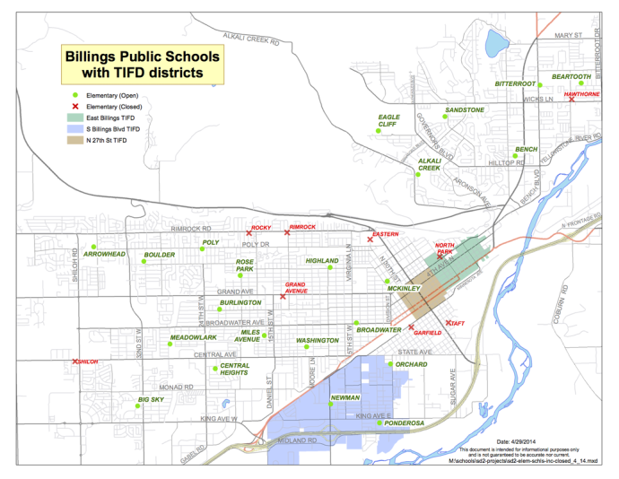 This map shows Billings area Tax Increment Finance Districts (TIF); one of the few remaining redevelopment tools used in 47 states. For best use of taxpayer dollars, schools and cities should collaborate on improvements.
Community determined priorities and plans can be superimposed on maps. Decisions can be compared and contrasted for specific community priorities, including proximity to the greatest number of students, walkability, co-location (shared use of public facilities including libraries, parks, auditoriums, etc.) neighborhood density, and existing infrastructure. School location decisions should be evaluated and coordinated with existing community plans. Maps can be used as a tool to discuss school boundary changes and school site changes. Opening, closing, consolidating or reconfiguring schools impact the entire community. Use maps to compare and contrast your options before a decision is made.
More collaborative community solutions will be required to support and sustain schools as well as other community plans, as cities across the nation grow and age. Census data from Billings, MT is used here to illustrate the importance of gathering data before decision making. The city of Billings has increased in total population, but the school aged population has been relatively flat since 1970. The mean age in Billings increased from 27 in 1970 to nearly 38 today. The Under 5 y/o population density is the greatest in the core of the city of Billings and ranges from 4-8 times greater than the rest of the school service/boundary area, yet several schools have been closed in this area
More collaborative community solutions will be required to support and sustain schools as well as other community plans, as cities across the nation grow and age. Census data from Billings, MT is used here to illustrate the importance of gathering data before decision making. The city of Billings has increased in total population, but the school aged population has been relatively flat since 1970. The mean age in Billings increased from 27 in 1970 to nearly 38 today. The Under 5 y/o population density is the greatest in the core of the city of Billings and ranges from 4-8 times greater than the rest of the school service/boundary area, yet several schools have been closed in this area
Homeless student population and location of temporary housing is another important factor that should be weighed in the school location decision. School location and transportation directly affect student access to before and after school programs. In Billings, the number of homeless students has increased annually; today more than 500 elementary aged students are homeless. The majority of temporary housing for the homeless population is located in the core of the city, near areas that have been affected by school closures. Because funding for education is enrollment based, the district managed dips in enrollment by closing schools.
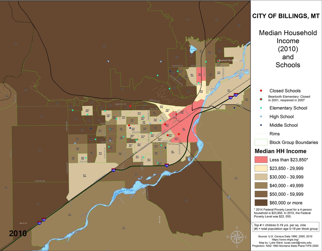
This map shows that the majority of school closures in Billings have been in neighborhoods at or near federal poverty level. These neighborhoods have historically been most densely populated with school-aged children (4-8 X more dense) when compared to the rest of the city, yet the area was again targeted for school closures.
At the same time, the city/public/private economic development agency was working to invest in the area and revitalize neighborhoods.
At the same time, the city/public/private economic development agency was working to invest in the area and revitalize neighborhoods.